
Research Objectives
The principal objectives are to record meteorological information for the Sapelo Island NERR’s site that can be used:
- As a reference for meteorological data for research projects on the reserve.
- To give meteorological context for our half hourly SWMP water quality data, and other long term environmental monitoring projects at the Reserve.
- To observe and characterize important events such as storms, heat and cold waves, droughts, and heavy rainfalls.
- To detect trends and characterize climate variability over the long-term.
(Click image to view current conditions.)
Research Methods
Campbell Scientific data telemetry equipment was installed at the Marsh Landing station on 02/15/2007 and transmits data to the NOAA GOES satellite, NESDIS ID #3B036592.
The transmissions are scheduled hourly and contain four (4) data sets reflecting fifteen minute data sampling intervals.
Upon receipt by the CDMO, the data undergoes the same automated primary QAQC process detailed in Section 2 above. The “real-time” telemetry data become part of the provisional dataset until undergoing secondary and tertiary QAQC and assimilation in the CDMO’s authoritative online database. Provisional and authoritative data are available at http://cdmo.baruch.sc.edu.
The 15 minute Data are collected in the following formats for the CR1000:
Averages from 5-second data:
- Air Temperature (°C)
- Relative Humidity (%)
- Barometric Pressure (mb)
- Wind Speed (m/s)
- Wind Direction (degrees)
- Battery Voltage (volts)
- Maximum and Minimum Air Temperature (°C) and their times from 5-second data (these data are available from the Reserve)
- Maximum Wind Speed (m/s) and time from 5-second data
- Wind Direction Standard Deviation (degrees)
Totals:
- Precipitation (mm)
- PAR (millimoles/m2)
- Cumulative Precipitation (mm)
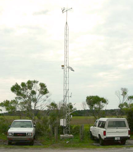
Site Location and Character
The site is located at N 31deg 25.068’, W 081deg 17.721’, about 15 feet above sea level.
All sensors are mounted on a 10m-aluminum tower located in the northern corner of the Marsh Landing parking lot on the southwest corner of the island. The parking lot surface is approximately a meter above the surrounding marsh.
The heights of the sensors on the tower are as follows:
- Temperature and relative humidity 2m
- Barometric pressure 1m
- PAR 3m
- Precipitation gauge 6m
- Wind sensor 10m
It is bordered with salt marsh to the north and south with transition into pine forest occurring 1/2 mi to the east.
On the immediate west lie the Duplin River and the ferry dock, which is also the location of our lower Duplin and marsh Landing Water Quality sampling sites.
The station is well exposed to all winds and weather with practically no blockage. This region is subject to multiple severe weather phenomena partially due to the proximity to the ocean.
These phenomena include:
- severe summer thunderstorms, which can cause drastic, localized drops in pressure, temperature, and heavy rains;
- powerful fall and winter frontal systems carrying prolonged strong winds (usually NNE), drastic and sudden drops in temperature and pressure, and long, steady rains;
- and of course the late summer and early fall hurricanes.
It must be noted that due to the remote location and proximity to the ocean, our weather patterns can vary greatly from those on the mainland; particularly temperatures which tend to moderate due to our being surrounded by water.
The nearest sites for comparison are the Grays Reef NOAA weather Buoy, located about 20nm East of Sapelo Island, and Glynco airport, located approximately 30 miles to the SE.